Customers' Choice
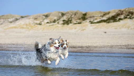
Pets stay free
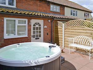
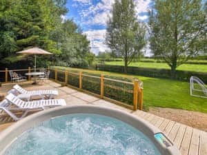
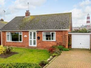
Hot Tub
Wifi
Car parking on site
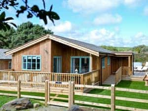
- 6 Guests
- 3 Bedrooms
- 2 Bathrooms
- 1 Pet
5
out of 5
7 nights
From
£837
Discover over 11,000 dog-friendly cottages across the UK, perfect for relaxed dog friendly holidays with the whole family. From coastal escapes to countryside stays, cottages.com makes it easy to find pet friendly accommodation that suits you. Dogs stay free in almost half of our cottages, meaning you can plan your break with clear pricing and no surprises, just pack the lead and go. Book now with just a £25 deposit and enjoy flexible cancellation for a stress-free getaway.

5
out of 5
7 nights
From
5
out of 5
7 nights
From

5
out of 5
7 nights
From

5
out of 5
7 nights
From

5
out of 5
7 nights
From

5
out of 5
7 nights
From

5
out of 5
7 nights
From

5
out of 5
7 nights
From

5
out of 5
7 nights
From

5
out of 5
7 nights
From
5
out of 5
7 nights
From
5
out of 5
7 nights
From
5
out of 5
7 nights
From
5
out of 5
7 nights
From
5
out of 5
7 nights
From
5
out of 5
7 nights
From

5
out of 5
7 nights
From

5
out of 5
7 nights
From

5
out of 5
7 nights
From

5
out of 5
7 nights
From
4.9
out of 5
7 nights
From
5
out of 5
7 nights
From

4.7
out of 5
7 nights
From

4.8
out of 5
7 nights
From

5
out of 5
7 nights
From
4.9
out of 5
7 nights
From
4.9
out of 5
7 nights
From

4.9
out of 5
7 nights
From

4.9
out of 5
7 nights
From
4.5
out of 5
7 nights
From
Not all pet friendly accommodation is created equal. A truly great dog friendly cottage goes well beyond a "dogs allowed" policy: it's built around how you and your dog actually spend a holiday together.
The most important feature for most dog owners is an enclosed garden. Not simply a private garden, but a fully fenced space where your dog can run off-lead without the risk of escaping onto a road or neighbouring field. Many cottages.com properties include this as a filter, so you can find exactly what you need before you book.
Pet welcome packs are another sign of a genuinely dog-aware property. The best include dog beds, water bowls, treats, and a toy waiting on arrival, small touches that make a real difference after a long drive. A growing number of cottages also provide dog washing stations, which are invaluable if you're staying near beaches or moorland where muddy paws are a given.
Beyond the cottage itself, location matters. Look for properties with walks directly from the door - national park trails, coastal paths, or open farmland - so morning exercise doesn't require a car. And with nearly 6,000 properties where dogs go free of charge, a dog friendly self catering break with cottages.com doesn't have to cost more than any other holiday.
Wherever you're heading, there's a dog friendly cottage waiting for you. Here are some of the most popular destinations for a dog friendly holiday in the UK, each with walks, warm welcomes and wide-open space.
Dog friendly cottages in the Lake District put you on the doorstep of some of England's finest fells and lakeside paths. From Windermere to Keswick, every valley offers long walks and dog-welcoming pubs to rest in after.
Dog friendly cottages in Cornwall come with some of the best beaches in the UK. Many Cornish beaches welcome dogs year-round, and the South West Coast Path gives you hundreds of miles of cliff-top walking right on the doorstep.
Dog friendly cottages in Yorkshire open up the Dales, the Moors, and some of England's most scenic market towns. Wide open moor gives dogs real room to run, while villages like Hawes and Masham are built for wandering.
Dog friendly cottages in Scotland are the ultimate adventure base. The Highlands offer loch-side walks, mountain trails and vast, empty glens: genuinely wild space that most dogs never get the chance to experience.
Dog friendly cottages in the Norfolk Broads sit beneath some of England's biggest skies. Long sandy beaches, the tranquil waterways of the Broads, and quiet country lanes make this one of the most relaxed corners of the UK for a dog friendly break.
Dog friendly cottages in Wales range from Pembrokeshire coastal retreats to Snowdonia mountain boltholes. Wales has right-to-roam over much of its open land, making it an especially rewarding destination for dogs and owners who love long walks.
Dog friendly cottages in Devon offer the best of two worlds: the wild moors of Dartmoor for off-lead exploring, and beaches like Croyde and Saunton Sands that welcome dogs year-round.
Dog friendly cottages in the Cotswolds put you among honey-stone villages, ancient bridleways and dog-friendly country pubs. It's the kind of landscape that feels made for an unhurried walk with a well-behaved dog at your side.
Dog friendly cottages in Northumberland sit near some of England's emptiest beaches, with Bamburgh and Alnmouth both welcoming dogs year-round. Add the wild Cheviot Hills and you have one of the most underrated dog friendly destinations in the country.
Dog friendly cottages in Dorset give access to the Jurassic Coast, a World Heritage walking route with dramatic cliffs, coves and dog-friendly beaches at Studland Bay and Lyme Regis.
Dog friendly cottages in Whitby combine a dramatic harbour town with direct access to the North York Moors. The beach below the abbey is dog-friendly, and moorland walks begin within minutes of most town-centre cottages.
Dog friendly cottages in the Peak District are perfect for walkers who want proper hills without travelling to Scotland. Stone-walled paths, open gritstone moors and market towns like Bakewell are all within easy reach.
Dog friendly cottages in Derbyshire give you the full Peak District experience with the added bonus of quieter valleys, working farms, and less footfall than the national park's most visited spots.
Dog friendly cottages on the Isle of Wight offer a slower pace, car-free cycling trails and a coastal path that circles the whole island. Several beaches welcome dogs year-round — and the ferry crossing is part of the adventure.
Holidays are better when no one gets left behind, especially your four-legged friends. At cottages.com, we believe dogs aren't just welcome, they're family. That's why our range of dog friendly holiday cottages UK-wide goes beyond the basics to create breaks that are truly more than dog friendly.
Choosing a dog friendly cottage gives you freedom, flexibility and comfort. Forget the hassle of kennels or worrying about pet sitters; instead, enjoy every moment together. Many of our cottages feature enclosed gardens, nearby walking routes and cosy spots for your pup to curl up after a day's adventure. Some even include thoughtful extras like welcome packs, dog washing stations and secure outdoor spaces, perfect for muddy paws and wagging tails.
Our promise is simple: we go further to make sure you and your dog feel completely at home. That means handpicking cottages in places where canine companions are not just accepted, but celebrated. With over 12,000 dog friendly cottages, we have the largest collection in the UK, and with nearly half offering dogs free of charge, we ensure our cottages put tails and smiles first.
What do dog-friendly cottages include? Dog-friendly cottages typically include enclosed gardens for safe off-lead play, dog beds and water bowls, and easy access to nearby walks. Many cottages.com properties go further with dedicated dog welcome packs — treats, a toy and sometimes a local dog-walking guide. A growing number also feature dog washing stations, ideal for beaches or moorland stays where muddy paws are inevitable. And with nearly 6,000 properties where dogs stay free, there's often no extra cost at all.
Can I find dog friendly cottages where dogs stay free? Yes. cottages.com has nearly 6,000 properties where dogs are welcome at no extra charge. When searching, use the "pets stay free" filter to show only these properties. You'll find them across every region of the UK, from the Lake District to Cornwall, at every price point and size.
What are the best dog friendly destinations in the UK? The most popular choices are the Lake District (endless fells and dog-welcoming pubs), Cornwall (year-round dog-friendly beaches), Yorkshire (open dales and moors), Scotland (vast Highlands with room to roam), and Norfolk (empty beaches and quiet Broads waterways). Each offers a very different landscape — the best destination depends on whether your dog prefers hills, coast or open countryside.
How many dogs can I bring to a dog friendly cottage? Most cottages.com properties accept one or two dogs, while some larger houses welcome three or more. Every listing clearly states the maximum number of pets permitted, so there's no guesswork. Use the pet count filter when searching to show only properties that fit your pack size, whether you're travelling with one small terrier or three large retrievers.
Are there dog friendly cottages with enclosed gardens? Yes — hundreds of cottages.com properties feature fully enclosed gardens, designed so dogs can run off-lead without the risk of escaping. Note that "enclosed" and "private" are not the same thing: a fully enclosed garden has secure fencing on all sides. Use the enclosed garden filter in your search to find only these properties across all UK destinations.
Collections
Collections by Destination